The fight against the dock in grassland management requires constant action. Despite careful cultivation, this weed recurs over and over again. Dock has an enormous potential for seed formation and retains its germination ability for decades.
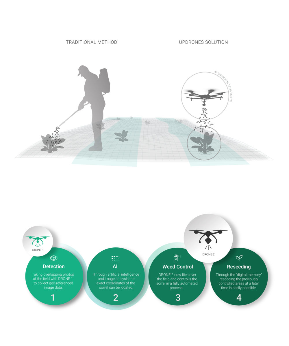
We offer an effective and sustainable solution by replacing the traditional method of chemical point control with a process using intelligent drones. During this process we learn about the land we observe. Therefore, we are able to provide areal information to our customers in the course of fighting weed. Another aspect of our innovative idea regards sustainability. Through the digital memory of our drones we can target the previously controlled spots over again and deploy grass seeds in order to close the gaps.
USP
In comparison to other offers we are different in the way that we focus rather on point control than on area wide spraying. Drones are already used in agriculture, but not in this specific way. Our drones are capable of targeting certain points in a fully automated way and recognize plants through AI. Another important aspect is the possibility of reseeding through the digital memory of our drones. This adds the benefit of sustainability to our project.
Target market
Our market is found in the cooperation with agriculturists. Starting in Austria, where there is around 160.000 farmers, we plan to expand to other countries in Europe, where grassland plays a big role in agriculture. In the long future we see us as a big player in precision farming, focusing on weed control from the air. Almost 60 billion euros flow into European agriculture every year. 70 percent of EU funds are spent per hectare without many extensive conditions, i.e. whoever manages a lot of land, gets a lot of money. This fact is already being discussed and the intention in the future is to link funding to far-reaching circumstances. The basis for this should also be our know-how from the data material we gather through earth observation. Our procedural way of working offers possibilities to find important interfaces, e.g. B2B as well as B2C. Also we see opportunities in other branches, where our technology could be applied as well.
Space connection
Our project’s connection with space is found in the field of remote sensing and earth observation, as well as in the use of high precision navigation. UPdrones enters the field of earth observation by using drones. In the form of digital pictures drones are acquiring the base material for the process we are working on. Through the process of our automated weed control we will extract the data for this specific use but obviously there is much more information in it. RTK and GNSS-satellite signals allow our drones precise positioning in the range of one centimeter [vertically and horizontally] by monitoring grassland. To show our process with drones within the technology of space we split it in an innovation part and a monitoring part. Through ‘UPdrones image processing‘ – our monitoring part - other services are included which demonstrate the scalability of the project.

