Copernicus Hackathon Graz

See the Big Picture

Thank you for participating!

Join the Copernicus Hackathon
Earth Observation Ideas for a Better Future
Who can participate?

The Copernicus Hackathon Graz is part of the European Union’s Copernicus Programme. Our aim is to motivate and inspire developers, entrepreneurs and the industry to develop innovative ideas for the betterment of society.

We are inviting all developers, scientists, researchers, entrepreneurs, designers and all Earth Observation and space enthusiasts to join us in the first Copernicus Hackathon taking place in Graz!

When: 15 – 16 October 2020

Where: Online / TU Graz, Austria

Be part of the challenge
Join us!
Economic Impact
Participate in the challenges and bring benefit to various economic sectors
Urban areas
Improving quality of life in urban areas with Earth Observation satellite data
As a fast-growing city Graz finds itself with limited settlement areas. Hence, its urban development aims to improve infrastructure in inner-city locations by developing energy-efficient, resource-saving and low-emission urban quarters with excellent quality of life. Future topics for this “Smart City” were defined in the fields of action economy, society, ecology, mobility and energy.

In addition, the set-up of recreational public spaces, the extension of attractive, green pedestrian zones and cycle path connections, the best possible access to public transport and the reduction of motorised individual transport are important objectives of the city.
Science Park Graz has a powerful support structure
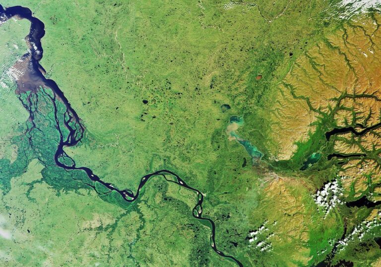
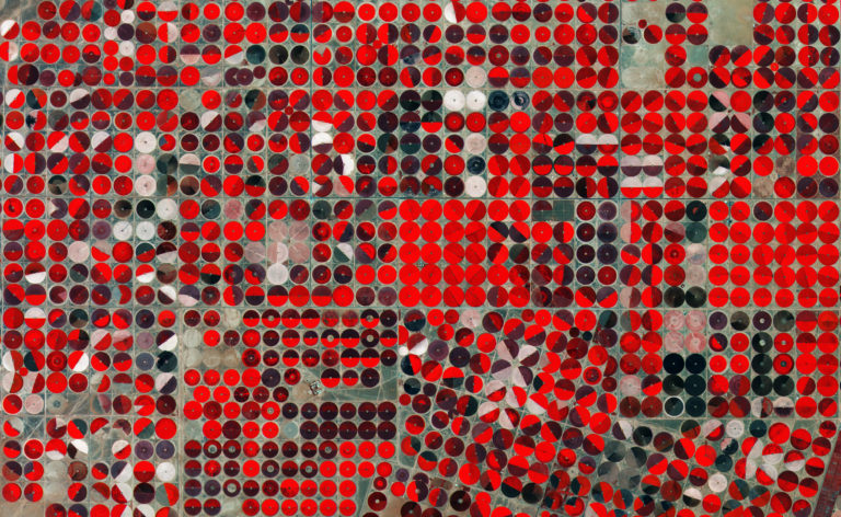
Land and agriculture
Development of practices that preserve the environment and sustain productivity
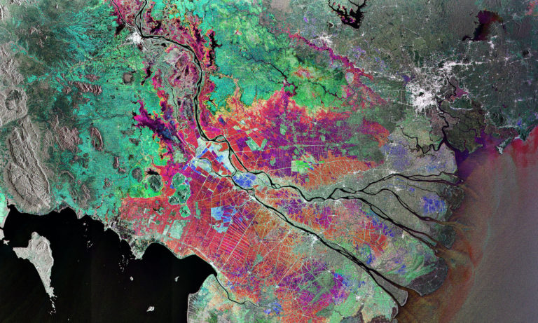
Agriculture is probably the most promising market in terms of the impact of Copernicus, especially through precision farming. Indeed, Copernicus helps to assess agricultural land use and trends, crop conditions and yield forecasts. It also supports input management, farm management recording and irrigation management.
The domains of application of Copernicus, however, are not limited to precision farming. They also include seasonal mapping of cultivated areas, water management and drought monitoring, as well as subsidy controls.
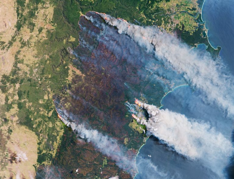
Forestry
Support the management of forests worldwide
In the domain of forestry, Earth Observation data is used to provide forest mapping and forest change mapping, and to produce maps supporting the completion of National forest inventories.
It also enables the production of forest cartographies which take into account different types of parameters, such as tree species or biophysical variables.
Earth Observation data is also used to monitor forest fires (for both real-time detection and tracking) or to monitor illegal logging.

Big Data and Environment
Use your knowledge to tackle environmental and big data challenges
Big Data
Remotely Sensed Big Data Management and Analytics Engine
Background
Heterogeneous Earth Observation (EO) data is being generated with higher pace than ever before. The immensely increasing remotely sensed data Volume, Velocity and Variety, poses the immediate challenge of managing the complex Big Data using techniques that support efficient consumption of theses datasets in diverse applied domains without expert knowledge of the remote sensing techniques.

Challenge
1. Developing models (data storage models to handle spatio-temporal data e.g. data cubes, data warehousng etc) and automated analytical tools (e.g. spatial data mining, ML etc ) that would support remotely sensed big data management and analytics for specific domains without expert RS knowledge of the user.
2. Semantics enrichment of remotely sensed data using data fusion techniques and/or Linked data approach.
Forest Fires
Predicting Forest Fires in Europe using Remotely Sensed EO Data
Background
Recent climatic variation and changes have drastically increased the risk of wildfires that pose threat to both human and wild life. The scale and intensity of the recent catastrophic wildfire events in Australia is an eye opener for the world and also demands for appropriate response from the researchers to invest more resources and efforts in studying wildfires at local, national and global scales.
RS is already being used for the detection and monitoring of active wildfire events. However, predicting wildfires based on climatic, meteorological and other relevant datasets at various scales timely and accurately is still a big challenge.

Challenge
Creating wildfire prediction models for Europe using remotely sensed and other related publicly available datasets.
Glacial Dynamics
Monitoring Glacial Dynamics using Remotely Sensed EO Data
Background
The intensity and frequency of disasters is increasing around the globe. This is mostly attribute to the climate change thus making it one of the important issues of our time. Mountain ecosystems are more vulnerable because of the sensitivity of glaciers towards climatic variations. Monitoring glacier dynamics as indicators of climate change are thus important for understanding and assessment of glacier related hazards.

Challenge
Developing models for monitoring glacial dynamics for predicting glacier behavior and sensitivity to climate variations.
COVID-19
Additional thematic challenge on COVID-19
COVID-19
Health-related, economic or societal impacts of the corona crisis
Tracking the movement of people and analyse the spread of corona infections, using GNSS and other data.

Using satellite images of the borders where long queues of lorries are forming at the border checks, to estimate the situation and provide quantified information on delays and the need for action.

Using satellite images of pollution levels or other indicators that can help analyse economic activity, infection levels, or other problems, and combine with other data sources to propose solutions.
Agenda
24 hours of hacking
15 - 16 October 2020

Day 1:

  • 13:00–13:30 – Opening session and introduction of the topics
  • 13:30–19:00 – Hacking and working with mentors
  • 19:00–19:30 – Business session – Business model
  • 20:00–23:00 – Hacking and working with mentors

Day 2:

  • 00:00–08:30 – Hacking
  • 09:00–10:00 – Business session – Perfecting pitch
  • 10:00–14:00 – Hacking and working with mentors
  • 14:00–15:00 – Presentations
  • 15:00–15:45 – Awards ceremony
Copernicus
Europe's eyes on Earth
What is Copernicus Hackathon?

Copernicus is the European Union’s Earth Observation Programme, looking at our planet and its environment for the ultimate benefit of all European citizens. It offers information services based on satellite Earth Observation and in situ (non-space) data.

Vast amounts of global data from satellites and from ground-based, airborne and seaborne measurement systems are being used to provide information to help service providers, public authorities and other international organisations improve the quality of life for the citizens of Europe. The information services provided are freely and openly accessible to its users.

Hackathons are gathering a large number of people with various fields of expertise and different skills with the aim of developing a software, starting from an idea and ending with an operational application.

The Copernicus Hackathon Programme, is bringing together developers, entrepreneurs and topic-specific experts to develop new applications based on Copernicus Earth Observation data and services. Copernicus Hackathons is giving people all over Europe the chance to come together and explore many application fields here on Earth with free and open space data from Copernicus.


Organizers
  • Technical University Graz
Partners
  • BMK
  • EODC
  • CCCA
Newsletter

Sign up for our newsletter to stay up to date on community news, project highlights and upcoming events.